How we got here
A trail network they promised to build, then called impossible.
The promise of public access through these woods runs back nearly 30 years. The developer offered to extend it, in writing and on their own plans, to win the bid. Watch that commitment shrink in three documented beats, ending with the moment they called the trails they drew “not feasible.”
-
Neighbors open the woods themselves.
Ward 7 Councilor Steve Dibble and more than 100 residents built a 200-foot, 6-foot-wide boardwalk across the Forest River salt marsh over two weekends. It was named the Volunteer Bridge.
-
Salem invests in an ADA-accessible trail.
The City spent $87,500, from a state recreational trails program and the City’s own capital improvement budget, to build a stone-dust, wheelchair-accessible trail from the Salem State South Campus parking lot trailhead to the Volunteer Bridge. Designed by Kyle Zick Landscape Architecture, it was the first public investment in the conservation area in more than 30 years. Then-Assistant Planner Tom Devine described it: “just about anyone, regardless of their ability, is able to traverse the main trunk trail.”
That accessible trunk trail was meant to be the start, not the end. Several miles of conservation-area trails extend through the woods to the west and south, the same routes the developer would later promise, in writing, to upgrade and connect. The public investment was already on the ground when they made that promise.
Sources: Salem News · Kyle Zick Landscape Architecture
-
The RFP opens, with conservation access as a stated priority.
DCAMM opens bidding on the 23-acre South Campus. At the announcement, Mayor Driscoll names three public goods the sale should deliver: housing, “improve access to and preservation of sensitive conservation areas,” and protect the historic Saint Chretienne convent.
Contemporary news coverage describes the site in its own voice as supporting “an entrance to the Forest River Conservation Area”, treating conservation access from the outset as a pre-existing public amenity of the property being sold.
Sources: Itemlive, “Salem State puts campus out to bid” · Salem News, Feb 2022
-
Avalon and Winn win the bid. Their proposal includes a promise.
DCAMM publicly recommends the AvalonBay + WinnDevelopment team. The Commonwealth describes their winning proposal in its own words:
“The proposal by the recommended Development Team includes… enhanced connectivity to the scenic Forest River Conservation Area.”
Beat 1 of 3The Commonwealth, naming the winning team
-
The developer files the same promise, in writing.
In a formal state filing, Avalon + Winn’s attorney lists the project’s components. Component #3, in the developer’s own words:
“…and (3) open recreational space and improvements to pedestrian hiking trails and trailheads connecting to the adjacent Forest River Conservation Area, to be undertaken jointly by the Proponents.”
Beat 2 of 3Developer’s attorney, in a formal filing
-
Purchase & Sale signed.
The Commonwealth formalizes the transfer to the Avalon + Winn team. The project is branded Forest River Residences.
-
The “enhanced connectivity” shrinks to a bike rack.
The Planning Board conducts its Section 8.9 Coastal Resiliency Overlay District Site Plan Review on the two-phase, up-to-485-unit project. Discussion centers on color selections and AvalonBay’s signage package. Phase I (AvalonBay, 340 units of new construction) is approved. Phase II (WinnDevelopment, up to 145 units of adaptive reuse) is continued to a future hearing. Asked what the promised conservation access actually amounts to, the developer’s representative answers on the record:
On the record, the developer’s representative described Avalon’s “enhanced connectivity” obligation as trailhead landscaping improvements, the addition of a bike rack, and removing trash from the trailhead area.
Beat 3 of 3Developer’s representative, Salem Planning Board
On the Record
The developer’s on-the-record offer: one additional public parking spot, bringing the total to five, for a development of nearly 1,000 residents. Plus invasive species removal.
The Contradiction
The same approved plans polish the trailhead entrance with landscaping and a bike rack, while the trail network their own proposal promised to build goes unbuilt. They will dress up the doorway to a conservation area they are declining to actually open.
The promise narrowed
A bike rack, trailhead landscaping, and trash removal at one location is maintenance, not access. It does not build the “series of accessible footpaths” weaving through the woodland with overlooks that the developer’s own proposal promised, and drew. The Commonwealth’s “enhanced connectivity” survives this reading only if it can mean “a bike rack”, which it cannot.
Source: Salem Planning Board public hearing, April 23, 2026.
-
The promise meets the very topography it was sold on.
At the Conservation Commission’s May 19 hearing, the developer’s own winning proposal came up directly. WinnDevelopment’s representative told the Commission that the promised conservation trails are “not feasible” to build. But that promise was never vague, and the terrain was never a surprise. The Avalon + Winn proposal said this, in its own words, in the section titled “Forest River Conservation Area Access”:
“…a series of accessible footpaths will weave through the existing woodland areas with overlook spaces on the western and southern sides of the park.”
Avalon + Winn proposal, “Forest River Conservation Area Access”
They did not just write it. They drew it. Their official Site Plan maps switchback trails climbing those exact slopes, labeled, in their own hand, “OVERLOOKS + TRAILS”, on the same hillside the proposal sold as a feature, describing how the design “nestles the development into the natural bowl created by the surrounding topography.” Decide for yourself:
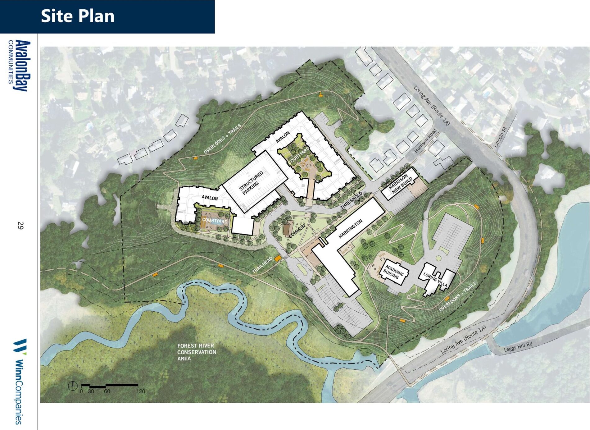
The developer’s own Site Plan (AvalonBay + WinnCompanies proposal, p. 29). The tightly-spaced lines are elevation contours, steep grade. The zig-zag paths are switchbacks, the standard way to carry an accessible trail up a slope. Both are labeled “OVERLOOKS + TRAILS.” These are the trails the developer told the Commission are “not feasible” to build. View the original document (PDF). A commissioner named it: a bait-and-switch
“Not feasible” is doing a great deal of work in that sentence. This plan was built to win a competitive public bid; its job was to present the most compelling possible vision for the land. The grades on that hill have not changed since the bid, and the developer was still showing this same plan view, with the same trail network drawn on it, at the August 12, 2024 community meeting and again at the December 9, 2024 Harrington Building meeting with Mayor Pangallo, when the developer needed City approval of the 40R. What changed is the willingness to pay for the trails once the property was secured. And at the hearing it was not only the trails, one appealing commitment after another from the winning proposal was now described as not feasible. A commitment WinnDevelopment made to win the bid binds WinnDevelopment, regardless of who speaks for the company today. The hearing was continued, to a July 1 special meeting the City later cancelled (see below).
Sources: Avalon + Winn proposal, “Forest River Conservation Area Access” & Site Plan (p. 29). Salem ConCom hearing, May 19, 2026.
-
Under pressure, the first trail comes back.
After the continued hearing, a Commission-ordered site walk on June 4, and weeks of public letters and testimony, the developer’s consultants filed a supplemental submission committing to a 5-foot-wide public footpath from Loring Avenue to the trailhead, the connection they had called “not feasible” on May 19, with Loring access to be written into the public easement “in perpetuity.” Their own letter calls the trail “likely the largest improvement” and admits the regulations they had blamed “originally appeared to be a barrier.” The terrain never changed. The pressure did. The filing also roughly doubles invasive-species removal and details trailhead improvements, and asks the Commission to issue the Order of Conditions. The trail network and overlooks from the winning plan, and the Volunteers Bridge, remain absent. See the full scoreboard.
Source: Supplemental Submission to NOI, Goddard Consulting LLC, June 9, 2026 (DEP File #064-0825), pp. 2–3, 6–7, 10; KMDG Conservation Area Improvements Plan, sheet L1.1.
-
You are here
ConCom takes the Order of Conditions back up.
The July 1 special meeting set for this step was cancelled by the City on June 25; the hearing will resume at a later date (tentatively July 21). When it does, the developer’s June 9 filing asks the Commission to issue the Order of Conditions, which makes that the likely decision night. Every discretionary waiver the developer needs, most critically the 25-foot No-Disturb Zone waiver, still lives here, along with the conditions the Commission can attach. June 9 proved the commitments move when the public shows up. The Order of Conditions is the one document that makes them binding: the Loring trail in the recorded easement, a fallback if MassDOT balks, maintenance that outlives the two-year monitoring window, the bridge, and the rest of the promised network. Public testimony in the room is what writes them in.
Not final. Emails help. Testimony wins.
Get the Next Hearing Date